
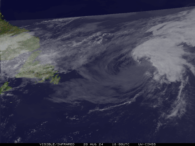
We have TD #4 now!
BULLETIN
Tropical Depression Four Advisory Number 1
NWS National Hurricane Center Miami FL AL042021
1100 AM EDT Mon Jun 28 2021
...NEW TROPICAL DEPRESSION FORMS OFF THE COAST OF SOUTH CAROLINA...
...TROPICAL STORM WARNING ISSUED FOR PORTIONS OF THE SOUTH
CAROLINA COAST...
SUMMARY OF 1100 AM EDT...1500 UTC...INFORMATION
-----------------------------------------------
LOCATION...31.9N 78.3W
ABOUT 145 MI...235 KM ESE OF BEAUFORT SOUTH CAROLINA
ABOUT 110 MI...180 KM ESE OF CHARLESTON SOUTH CAROLINA
MAXIMUM SUSTAINED WINDS...35 MPH...55 KM/H
PRESENT MOVEMENT...WNW OR 300 DEGREES AT 16 MPH...26 KM/H
MINIMUM CENTRAL PRESSURE...1013 MB...29.92 INCHES
WATCHES AND WARNINGS
--------------------
CHANGES WITH THIS ADVISORY:
A Tropical Storm Warning has been issued for a portion of the coast
of South Carolina from Edisto Beach northeastward to South Santee
River.
SUMMARY OF WATCHES AND WARNINGS IN EFFECT:
A Tropical Storm Warning is in effect for...
* Edisto Beach to South Santee River South Carolina
A Tropical Storm Warning means that tropical storm conditions are
expected somewhere within the warning area, in this case within the
next 12 hours.
For storm information specific to your area, including possible
inland watches and warnings, please monitor products issued by your
local National Weather Service forecast office.
DISCUSSION AND OUTLOOK
----------------------
At 1100 AM EDT (1500 UTC), the center of Tropical Depression Four
was located near latitude 31.9 North, longitude 78.3 West. The
depression is moving toward the west-northwest near 16 mph (26 km/h)
and this general motion is expected to continue for the next couple
of days. On the forecast track, the center of the tropical cyclone
should make landfall along coast of South Carolina in the warning
area later this evening.
Maximum sustained winds are near 35 mph (55 km/h) with higher gusts.
Some slight strengthening is expected today, and the depression is
forecast to become a tropical storm before it makes landfall. Rapid
weakening is forecast after landfall occurs.
The estimated minimum central pressure is 1013 mb (29.92 inches).
HAZARDS AFFECTING LAND
----------------------
Key messages for Tropical Depression Four can be found in the
Tropical Cyclone Discussion under AWIPS header MIATCDAT4, WMO header
WTNT44 KNHC and on the web at
www.hurricanes.gov/graphics_at4.shtml?key_messages.
WIND: Tropical storm conditions are expected to first reach
the coast within the warning area by late this afternoon, making
outside preparations difficult or dangerous.
RAINFALL: The depression could produce 1 to 3 inches of rainfall
with locally higher amounts along the immediate coasts of Georgia
and southern South Carolina. This region has been dry, limiting
potential widespread flooding impacts, however, local flooding
impacts, especially in urban areas along the southern South Carolina
and Georgia coasts, cannot be ruled out at this time.
Farther inland, 1 to 2 inches of rainfall is possible across Upstate
South Carolina, the Piedmont of Georgia, and into northeastern
Alabama.
STORM SURGE: The combination of storm surge and the tide will cause
normally dry areas near the coast to be flooded by rising waters
moving inland from the shoreline. The water could reach the
following heights above ground somewhere in the indicated areas if
the peak surge occurs at the time of high tide...
Port Royal Sound, SC to South Santee River, SC...1 to 3 ft
Surge-related flooding depends on the relative timing of the surge
and the tidal cycle, and can vary greatly over short distances. For
information specific to your area, please see products issued by
your local National Weather Service forecast office.
NEXT ADVISORY
-------------
Next intermediate advisory at 200 PM EDT.
Next complete advisory at 500 PM EDT.
Atlantic Hurricane Season Discussion
Re: Atlantic Hurricane Season Discussion
Mike B.
Miamisburg, OH
The KING of the domes!

Miamisburg, OH
The KING of the domes!
Re: Atlantic Hurricane Season Discussion
We now have Danny!
Tropical Storm Danny Tropical Cyclone Update
NWS National Hurricane Center Miami FL AL042021
305 PM EDT Mon Jun 28 2021
...DEPRESSION STRENGTHENS TO A TROPICAL STORM...
Doppler radar data from Charleston, South Carolina, along with
preliminary data from an Air Force Reserve reconnaissance aircraft,
indicate that the depression has strengthened and is now Tropical
Storm Danny. The maximum sustained winds are estimated to be 40 mph
(65 km/h) with higher gusts.
A Weatherflow station at Folly Beach, South Carolina, recently
reported a wind gust of 41 mph (66 km/h).
SUMMARY OF 305 PM EDT...1905 UTC...INFORMATION
----------------------------------------------
LOCATION...32.2N 79.7W
ABOUT 60 MI...95 KM ESE OF BEAUFORT SOUTH CAROLINA
ABOUT 45 MI...70 KM SSE OF CHARLESTON SOUTH CAROLINA
MAXIMUM SUSTAINED WINDS...40 MPH...65 KM/H
PRESENT MOVEMENT...WNW OR 325 DEGREES AT 16 MPH...26 KM/H
MINIMUM CENTRAL PRESSURE...1014 MB...29.94 INCHES
Mike B.
Miamisburg, OH
The KING of the domes!
Miamisburg, OH
The KING of the domes!
-
tron777

- Major Hurricane
- Posts: 20377
- Joined: Fri Feb 26, 2021 5:10 pm
- Location: Burlington, KY
- Contact:
Re: Atlantic Hurricane Season Discussion
Wow... that didn't take long! 

-
tron777
- Major Hurricane
- Posts: 20377
- Joined: Fri Feb 26, 2021 5:10 pm
- Location: Burlington, KY
- Contact:
Re: Atlantic Hurricane Season Discussion
Danny is now a remnant low over GA moving WNW at 17 mph. This one will son fade off the map. The Eastern ATL wave is now at a 40% chance for development in the next 5 days.
Re: Atlantic Hurricane Season Discussion
Danny is the first tropical to hit South Carolina in June since 1867. Again not a major system but the feel of the tropics is being felt here in northern South Carolina.
-
tron777
- Major Hurricane
- Posts: 20377
- Joined: Fri Feb 26, 2021 5:10 pm
- Location: Burlington, KY
- Contact:
Re: Atlantic Hurricane Season Discussion
We've got a high chance now, 70% with a strong tropical wave in the E. ATL. Eventually, in the next 7-10 days, it is forecast to become a named system and possibly impact the Gulf again.
Re: Atlantic Hurricane Season Discussion
Lots of solutions in play with this one.....GFS says maybe Florida, NAVGEM says maybe Yucatan, EPS says maybe Texas. LOL
You do not have the required permissions to view the files attached to this post.
Mike B.
Miamisburg, OH
The KING of the domes!
Miamisburg, OH
The KING of the domes!
-
tron777
- Major Hurricane
- Posts: 20377
- Joined: Fri Feb 26, 2021 5:10 pm
- Location: Burlington, KY
- Contact:
Re: Atlantic Hurricane Season Discussion
It's going to depend on the timing of the next incoming cold front (it's position) in relation to where this system goes downs the road. I think it'll be a Gulf of Mexico system again but like you said Mike, the door is wide open as to who gets impacted.
-
tron777
- Major Hurricane
- Posts: 20377
- Joined: Fri Feb 26, 2021 5:10 pm
- Location: Burlington, KY
- Contact:
Re: Atlantic Hurricane Season Discussion
TS Elsa is born! This one may impact the Gulf Coast next week.
BULLETIN
Tropical Storm Elsa Advisory Number 3
NWS National Hurricane Center Miami FL AL052021
500 AM AST Thu Jul 01 2021
...DEPRESSION BECOMES TROPICAL STORM ELSA...
SUMMARY OF 500 AM AST...0900 UTC...INFORMATION
----------------------------------------------
LOCATION...9.4N 48.8W
ABOUT 865 MI...1390 KM ESE OF THE WINDWARD ISLANDS
MAXIMUM SUSTAINED WINDS...40 MPH...65 KM/H
PRESENT MOVEMENT...W OR 275 DEGREES AT 25 MPH...41 KM/H
MINIMUM CENTRAL PRESSURE...1006 MB...29.71 INCHES
WATCHES AND WARNINGS
--------------------
CHANGES WITH THIS ADVISORY:
The Meteorological Service of Barbados has issued a Tropical
Storm Warning for St. Vincent and the Grenadines.
SUMMARY OF WATCHES AND WARNINGS IN EFFECT:
A Tropical Storm Warning is in effect for...
* Barbados
* Martinique
* St. Lucia
* St. Vincent and the Grenadines
A Tropical Storm Watch is in effect for...
* Guadeloupe
A Tropical Storm Warning means that tropical storm conditions are
expected somewhere within the warning area within 36 hours.
A Tropical Storm Watch means that tropical storm conditions are
possible within the watch area, in this case within 36 hours.
Interests elsewhere in the Windward Islands, Leeward Islands, the
Virgin Islands, Puerto Rico, the Dominican Republic, and Haiti
should monitor the progress of this system. Additional watches and
warnings will likely be required later today.
-
tron777
- Major Hurricane
- Posts: 20377
- Joined: Fri Feb 26, 2021 5:10 pm
- Location: Burlington, KY
- Contact:
Re: Atlantic Hurricane Season Discussion
TS Elsa has winds of 45 mph this afternoon cooking to the WNW at 28 mph. This thing is really moving!
-
MVWxObserver
- Hurricane
- Posts: 5523
- Joined: Fri Feb 26, 2021 7:48 pm
- Location: Greenville, OH
Re: Atlantic Hurricane Season Discussion
"Born free, out there on the ocean ...lah lah lah lah laaaah lah ...she is born free."
Thankfully at least from an update I saw on TWC earlier today via the NHC, she's not forecast to become a 'lion' of a storm down the road.
Thankfully at least from an update I saw on TWC earlier today via the NHC, she's not forecast to become a 'lion' of a storm down the road.
-
tron777
- Major Hurricane
- Posts: 20377
- Joined: Fri Feb 26, 2021 5:10 pm
- Location: Burlington, KY
- Contact:
Re: Atlantic Hurricane Season Discussion
I agree Eric. Most guidance thus far that I've seen has a strong TS or a weak 'cane at this point.
-
tron777
- Major Hurricane
- Posts: 20377
- Joined: Fri Feb 26, 2021 5:10 pm
- Location: Burlington, KY
- Contact:
Re: Atlantic Hurricane Season Discussion
Elsa has winds of 60 mph now still moving WNW at 28 mph as she approaches the Windward and Leeward Islands today.
-
Bgoney

- Tropical Storm
- Posts: 3654
- Joined: Fri Feb 26, 2021 7:09 pm
- Location: East clermont, 3mls north of Williamsburg
Re: Atlantic Hurricane Season Discussion
EU is even having trouble now with tropical systems. Looking like a solution closer to the GFS as far as a stronger system
Proud owner of Best Guess Forecast Center (BGFC)
Former owner of Gut Feeling Forecast (GFF) and Doppler Infinity
I know just enough about weather to be dangerous!
Former owner of Gut Feeling Forecast (GFF) and Doppler Infinity
I know just enough about weather to be dangerous!
-
tron777
- Major Hurricane
- Posts: 20377
- Joined: Fri Feb 26, 2021 5:10 pm
- Location: Burlington, KY
- Contact:
Re: Atlantic Hurricane Season Discussion
The ECMWF folks did an upgrade a while back to address the issue that the Euro has with tropical cyclones. That's the funny part.
-
Bgoney
- Tropical Storm
- Posts: 3654
- Joined: Fri Feb 26, 2021 7:09 pm
- Location: East clermont, 3mls north of Williamsburg
Re: Atlantic Hurricane Season Discussion
Elsa is a hurricane now. Recon just finished up
Proud owner of Best Guess Forecast Center (BGFC)
Former owner of Gut Feeling Forecast (GFF) and Doppler Infinity
I know just enough about weather to be dangerous!
Former owner of Gut Feeling Forecast (GFF) and Doppler Infinity
I know just enough about weather to be dangerous!
-
tron777
- Major Hurricane
- Posts: 20377
- Joined: Fri Feb 26, 2021 5:10 pm
- Location: Burlington, KY
- Contact:
Re: Atlantic Hurricane Season Discussion
I was just about ready to post this lol Bad call on my part "listening" to the models. Eeeshhh... they are already busting on this system.
-
Bgoney
- Tropical Storm
- Posts: 3654
- Joined: Fri Feb 26, 2021 7:09 pm
- Location: East clermont, 3mls north of Williamsburg
Re: Atlantic Hurricane Season Discussion
.ELSA STRENGTHENS TO A HURRICANE...
Location: 13.1°N 60.1°W
Moving: WNW at 28 mph
Min pressure: 995 mb
Max sustained: 75 mph
Location: 13.1°N 60.1°W
Moving: WNW at 28 mph
Min pressure: 995 mb
Max sustained: 75 mph
Proud owner of Best Guess Forecast Center (BGFC)
Former owner of Gut Feeling Forecast (GFF) and Doppler Infinity
I know just enough about weather to be dangerous!
Former owner of Gut Feeling Forecast (GFF) and Doppler Infinity
I know just enough about weather to be dangerous!
-
Bgoney
- Tropical Storm
- Posts: 3654
- Joined: Fri Feb 26, 2021 7:09 pm
- Location: East clermont, 3mls north of Williamsburg
Re: Atlantic Hurricane Season Discussion
At the warp speed Elsa is moving , I would think its more difficult for recon to get accurate measurements in some categories
Proud owner of Best Guess Forecast Center (BGFC)
Former owner of Gut Feeling Forecast (GFF) and Doppler Infinity
I know just enough about weather to be dangerous!
Former owner of Gut Feeling Forecast (GFF) and Doppler Infinity
I know just enough about weather to be dangerous!
-
tron777
- Major Hurricane
- Posts: 20377
- Joined: Fri Feb 26, 2021 5:10 pm
- Location: Burlington, KY
- Contact:
Re: Atlantic Hurricane Season Discussion
What I find unique about Elsa is that despite it moving so fast, it has actually been able to develop. Typically when a tropical system is moving that fast, it has a tough time getting its act together. This has not been the case so far with Elsa so probably a reason why the models are busting with the intensity forecast. Just another anomalous situation in the world of meteorology.
-
Bgoney
- Tropical Storm
- Posts: 3654
- Joined: Fri Feb 26, 2021 7:09 pm
- Location: East clermont, 3mls north of Williamsburg
Re: Atlantic Hurricane Season Discussion
Satellite imagery indicates that Elsa has become better organized,
and radar data from Barbados and Martinique have shown attempts at
eye formation. The formative northern eyewall passed over Barbados
near 11-12Z, and hurricane-force winds were reported there at that
time. The initial intensity is set at 65 kt based on those data. It
should be noted that reports from an Air Force Reserve Hurricane
Hunter aircraft suggest that the circulation is not well-developed
at 700 mb, possible due to the rapid forward speed.
The initial motion is 290/25. There is little change to the
forecast track or the forecast guidance since the last advisory.
The guidance is in good agreement on a rapid west-northwestward
notion to near the south coast of the Dominican Republic by 36 hr.
After that, the general consensus is that Elsa should turn northward
by 96 h through a weakness in the subtropical ridge created by a
mid-latitude trough. However, the guidance is quite divergent
around this consensus, with possible tracks ranging from a
west-northwestward motion through the Yucatan Channel or western
Cuba to a northward motion through the Bahamas. Thus, the latter
portion of the track forecast remains low confidence.
The intensity forecast calls for a little more strengthening during
the next 36 h as Elsa moves through an environment of light
westerly shear. After that, land interaction, along with less
favorable upper-level winds over the Gulf of Mexico, is likely to
cause weakening. The new NHC intensity forecast shows major
adjustments from the previous forecasts based primarily on the
initial intensity.
It should be noted that the average NHC track errors are 175 miles
and 200 miles at days 4 and 5, respectively. Given the
larger-than-normal uncertainty and because hazards will extend well
away from the center of the storm, users are urged to not focus on
the exact forecast points.
Proud owner of Best Guess Forecast Center (BGFC)
Former owner of Gut Feeling Forecast (GFF) and Doppler Infinity
I know just enough about weather to be dangerous!
Former owner of Gut Feeling Forecast (GFF) and Doppler Infinity
I know just enough about weather to be dangerous!
-
Bgoney
- Tropical Storm
- Posts: 3654
- Joined: Fri Feb 26, 2021 7:09 pm
- Location: East clermont, 3mls north of Williamsburg
Re: Atlantic Hurricane Season Discussion
Reading between the lines from the NHC, although the GFS has been more correct in the early and current stages , they are not buying the mid range forecast from GFS and leaning towards the EU atm with effects to the US
Proud owner of Best Guess Forecast Center (BGFC)
Former owner of Gut Feeling Forecast (GFF) and Doppler Infinity
I know just enough about weather to be dangerous!
Former owner of Gut Feeling Forecast (GFF) and Doppler Infinity
I know just enough about weather to be dangerous!
Re: Atlantic Hurricane Season Discussion
Yes I see the Hurricane has been named and rather impressive this early in the game. How strong and maybe it gets to a cat2 but where will it end up going and will there be any affect on the local weather. The gfs is bringing it into the gom just off the Florida coast while the latest cmc is having it stay in the Atlantic just off the eastern coast of Florida and this keeps most of the system to our southeast. Wait to the latest Euro later today and see how it shows the path.
-
tron777
- Major Hurricane
- Posts: 20377
- Joined: Fri Feb 26, 2021 5:10 pm
- Location: Burlington, KY
- Contact:
Re: Atlantic Hurricane Season Discussion
Hurricane Elsa Intermediate Advisory Number 9A
NWS National Hurricane Center Miami FL AL052021
200 PM AST Fri Jul 02 2021
...ELSA STRENGTHENS MORE AS IT MOVES INTO THE EASTERN CARIBBEAN
SEA...
SUMMARY OF 200 PM AST...1800 UTC...INFORMATION
----------------------------------------------
LOCATION...13.7N 62.5W
ABOUT 95 MI...155 KM WNW OF ST. VINCENT
ABOUT 580 MI...935 KM ESE OF SANTO DOMINGO DOMINICAN REPUBLIC
MAXIMUM SUSTAINED WINDS...85 MPH...140 KM/H
PRESENT MOVEMENT...WNW OR 290 DEGREES AT 29 MPH...46 KM/H
MINIMUM CENTRAL PRESSURE...991 MB...29.26 INCHES
