18Z HRRR shows a few scattered super cells over SE IN this evening working into Cincy and points NE from there. For NKY, we don't see much until 11 or midnight with that line that models have shown all day long now. Then we still may see one more line in a weakened state with the cold front around 3 or 4am.
The uncertainties with this event are going to be CAPE as well as when the cap decides to break.
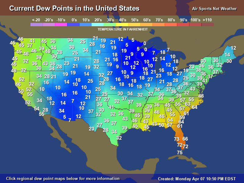
Even though St.Louis is 81 degrees the dew point has dropped back into the upper 40's. Moisture input has been tough to get much of the winter and this trend looks to continue at least for the moment.
tpweather wrote: ↑Tue Feb 27, 2024 2:44 pm
Even though St.Louis is 81 degrees the dew point has dropped back into the upper 40's. Moisture input has been tough to get much of the winter and this trend looks to continue at least for the moment.
Yeah.... mixing has led to lower dews and higher temps in that area. Not what you want for severe wx in my opinion. We see that sometimes occur here in our area. For today... models have done well with the dewpoints but have failed on temps due to the extra clouds. IMO unless something comes together this evening that I am not seeing, I think the severe threat is going to be more isolated for us. Widespread certainly is doable to our NW. I would watch it in S IN due to the modeled super cells that continue to show up.
I agree Les and those isolated super cells can lead to tornado's. Still need to watch this evening and for us still believe more of a line of storms come through but that may just be brief heavy rain and strong winds. This morning when I was walking the winds were howling and the sun was out and I thought this is going to be a nice outbreak. Since about 10a or so the clouds returned and have been socked in since then.
Another item that I always turn to is the return of moisture and usually when I feel this increase in my body this is a nice sign. Today I have nothing and no its not 100p/c correct but funny in the spring and summer about 1 hour or so before a thunderstorm hits I will start to break out in a sweat. My wife laughs but agrees and sure she would like to send me to the circus.
I always worry about the power outages, especially when it turns colder like tomorrow. Although we're not expected anything frigid, it still will be cold with some wind chills.
Sounds like we'll have to monitor the conditions overnight for some severe weather which can interrupt our sleep patterns, Ugh!
84 in St.Louis and 32 in Omaha. The system in the northern stream is getting stronger and that is why the enhanced severe weather near Chicago later today and yes we still have an enhanced area in the Ohio Valley mainly along the river and nearby areas.
With this kind of set-up, glad the MLB regular season hasn't started and the Redlegs not having a home night game. Time-wise for the Tri-state e.g. would have made potentially for an interesting toward the game ender and drive home for fans.
Still holding steady at 63 here in G'ville and 65 in DAY.
Update: Now at 61 here and 63 DAY.
Last edited by MVWxObserver on Tue Feb 27, 2024 4:31 pm, edited 1 time in total.
tpweather wrote: ↑Tue Feb 27, 2024 3:44 pm
84 in St.Louis and 32 in Omaha. The system in the northern stream is getting stronger and that is why the enhanced severe weather near Chicago later today and yes we still have an enhanced area in the Ohio Valley mainly along the river and nearby areas.
Amazing in the 80s there in MO. I have some cousins who reside in O'Fallon, MO near St. Louis.
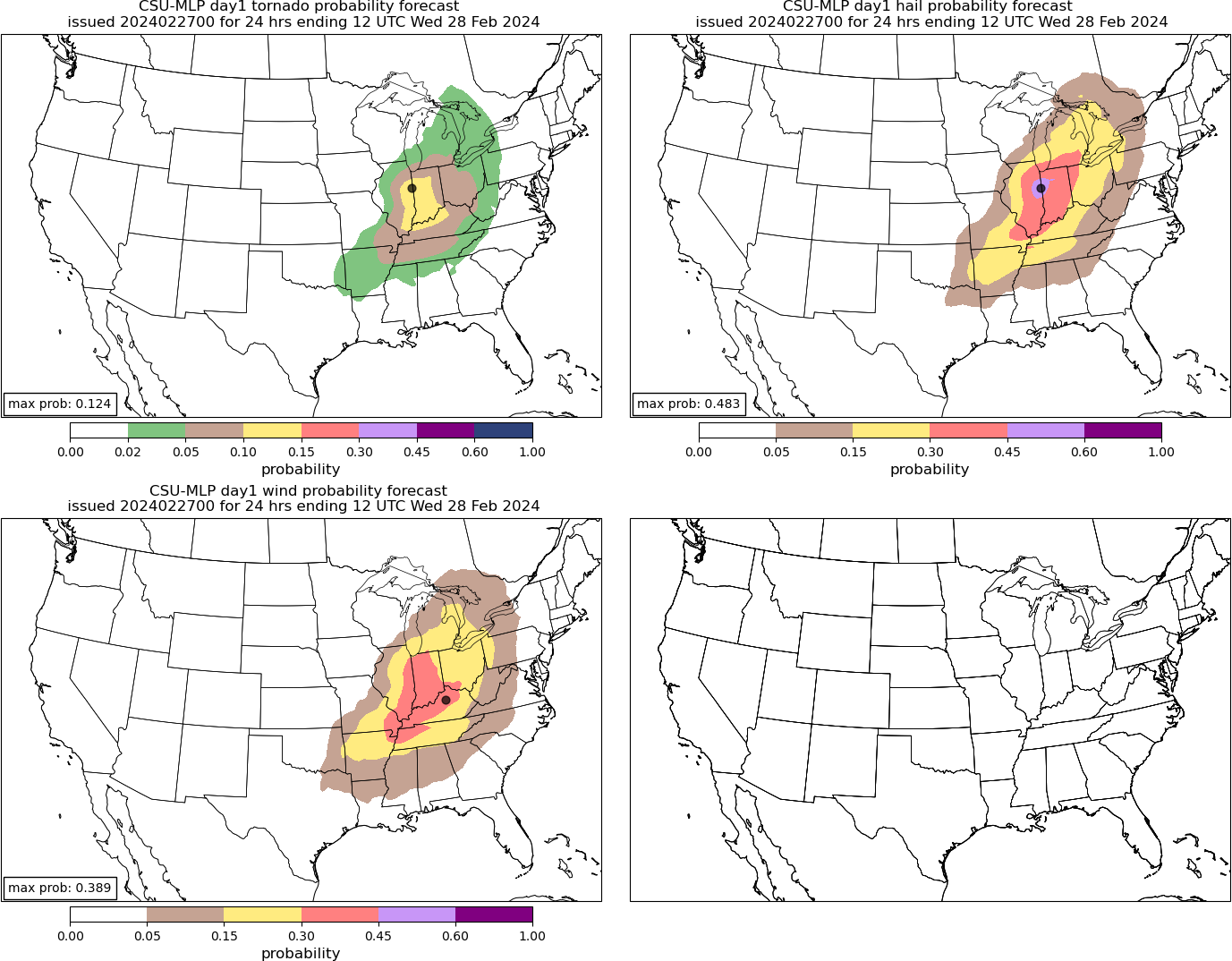
OH Valley This Evening and Overnight
Overall expectation outlined in the previous outlook remains unchanged for tonight across the OH Valley. As the night progresses, activity will likely evolve into fast-moving bowing structures with an enhanced risk of damaging wind gusts and a few tornadoes. Given the strengthening low-level flow, destructive wind gusts around 75 mph are possible, with a strong tornado or two possible as well.
..Mosier.. 02/27/2024
.PREV DISCUSSION… /ISSUED 1026 AM CST Tue Feb 27 2024/
OH Valley
A fast-moving southern-stream shortwave trough over the central Plains will track eastward today and begin affecting parts of MO by late afternoon or early evening. Most 12z guidance suggests that at least isolated thunderstorm development will begin around/after dusk as the large-scale forcing overspreads the northern extent of moist/unstable air mass from southwest MO into southern IL. These storms will intensify and track eastward overnight roughly along the OH river, moving into parts of OH/WV/PA by early morning Wednesday. Initial storms may be discrete, with sufficient vertical shear for supercells structures capable of all severe hazards. As the night progresses, activity will likely evolve into fast-moving bowing structures with an enhanced risk of damaging wind gusts and a few tornadoes. A strong tornado or two cannot be ruled out. Have added an ENH risk area for this scenario overnight.
Proud owner of Best Guess Forecast Center (BGFC)
Former owner of Gut Feeling Forecast (GFF) and Doppler Infinity
I know just enough about weather to be dangerous!
They are expecting the low level jet to be quite strong and though this usually happens once we get into spring the set up in that regards is possible. Hoping just some strong storms without the tornado's but the chance is there but even trying to pinpoint where they may show up will not be know for several hours. Full sun in all of southern Illinois and extremes western Kentucky so they have had enough sun to help with this severe outbreak plus the dry line Bgoney mentioned is another key part of the equation
It is a short-range, high resolution forecast model that only runs for severe weather events. My brother-in-law has been working on the web development UI side for this model. It runs every 30 minutes with 10 minute forecast intervals. The runs on the hour forecast 6 hours into the future while the runs on the half-hours forecast 3 hours out. It has a lot of severe weather parameter tracking. I've found it to be pretty reliable for very short term high resolution forecasts on storm cell initiation and tracks.